|
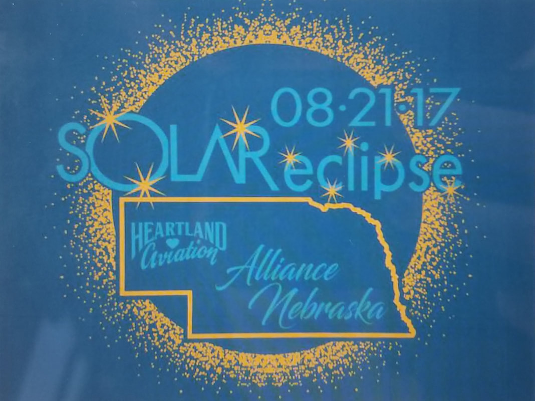
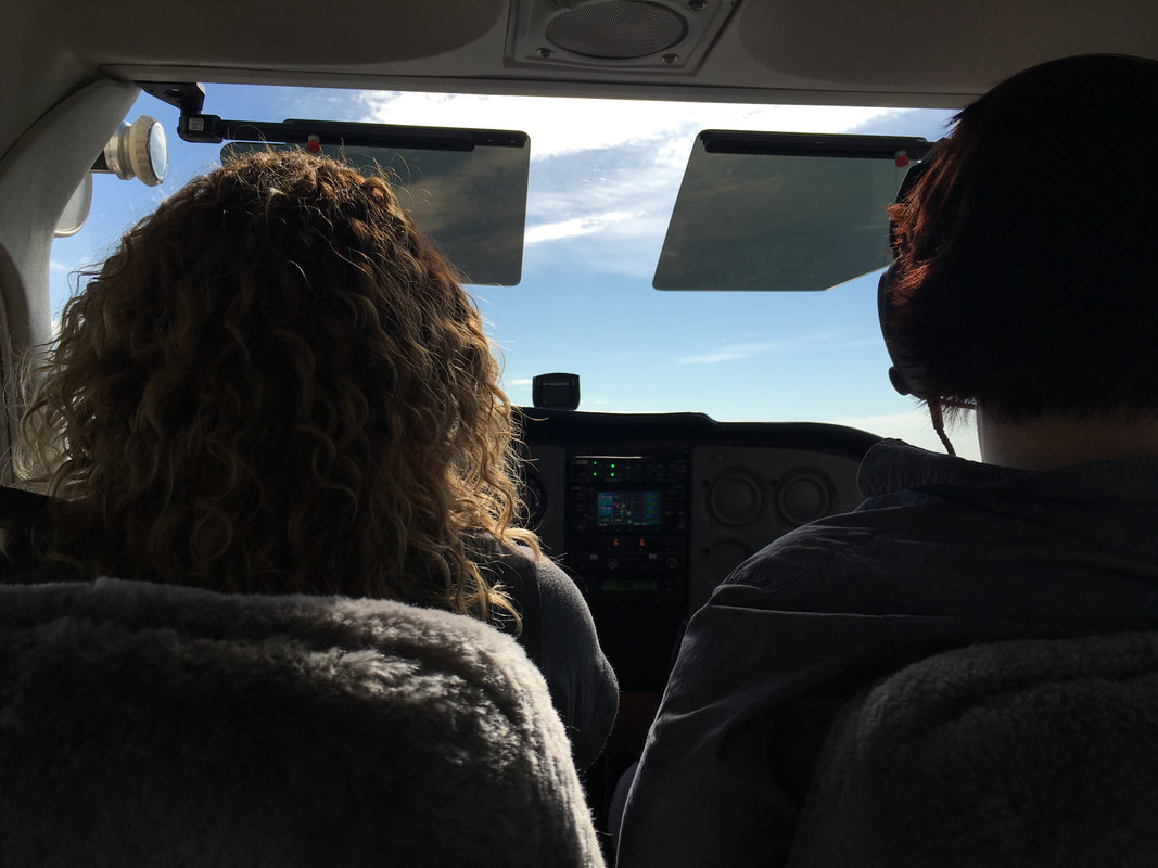
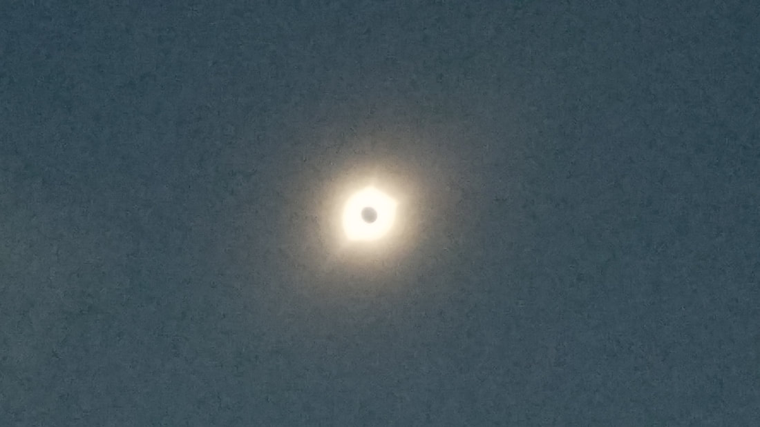
The (total) solar eclipse of 2017 was one of those memorable life experiences one remembers forever. A total solar eclipse happens when the Moon passes between the Sun and Earth, completely blocking the face of the Sun. The sky darkens as if it were dawn or dusk. A couple of girlfriends and I flew from Denver, CO to Alliance, NE for it. I landed the Cessna 172 we were in, parked it on the side of a (fairly full) taxiway, and watched it right by the airplane. It was wicked! In a short time, we went from a calm day to a light windy day and from day light to an eerie dusk and... back.
  But we were not the only ones who thought it was bizarre and cool at the same time. The airport beacon turned on during totality. And, did you know that, when a solar eclipse reaches totality, nocturnal wildlife sometimes wakes up thinking that it’s nighttime, and non-nocturnal wildlife think it’s time to sleep?
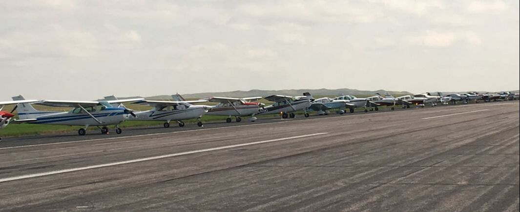
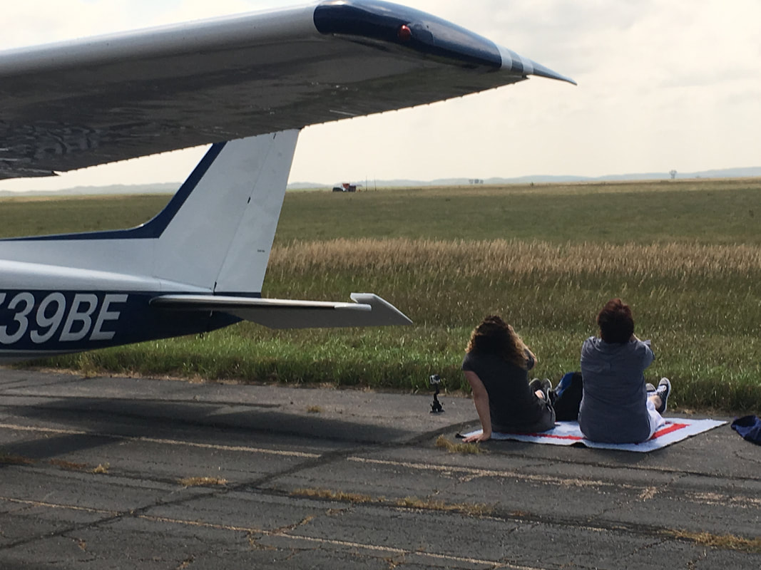
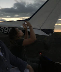
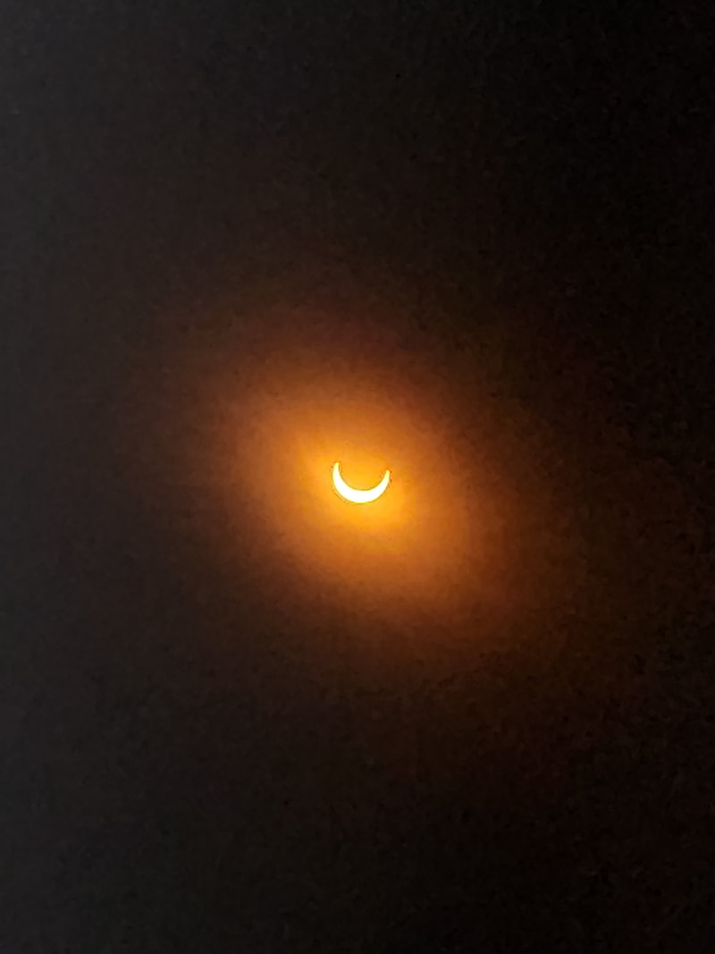
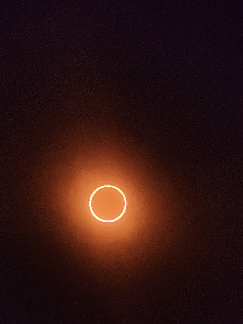
(Apologies for the poor quality of some of the pictures. The quality of phone photography in 2017 was not that of 2023! Plus, we were more focused on enjoying it than photographing it) Guess who else was there? John and Martha King, ladies and gentlemen! 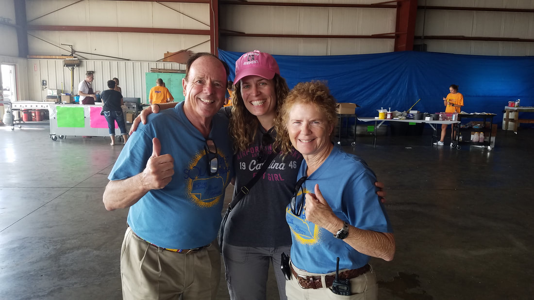 When I learned that two more eclipses were going through the U.S., I immediately made plans to view and experience both of them. There was an annular solar eclipse on October 14, 2023 and there will be another total solar eclipse on April 8, 2024. 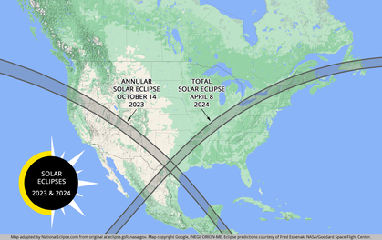 We watched the annular eclipse, also referred to as “ring of fire,” from Balloon Fiesta in Albuquerque since the dates matched. Two for one! Double the coolness factor although, unfortunately, we didn’t watch the eclipse from a balloon but from the grounds! The annular eclipse lasted a lot longer than the total; it was really cool to watch the slow movement of the Moon across the Sun and the perfect ring at the top of the eclipse. I can’t choose one eclipse over the other, to be honest; they are both very cool, very different, and equally impressive.
The 2024 total eclipse, like the one I witnessed in 2017, will cross the U.S. from Texas to Maine, passing over Mexico and Canada as well. Have YOU made plans yet? The next total solar eclipse that will be able to be seen from the contiguous U.S. won’t be until August 23, 2044 so time to plan for the 2024 one! Will it be going over you or will you have to fly somewhere to see it? We’ll be watching it from our cabin in Leakey, TX (49R is the airport identifier). Maybe we’ll see you there! Remember to use special eye protection (eclipse glasses or a specialized solar filter) to see eclipses. However, with the total eclipse, the protection can be removed during the peak of it. 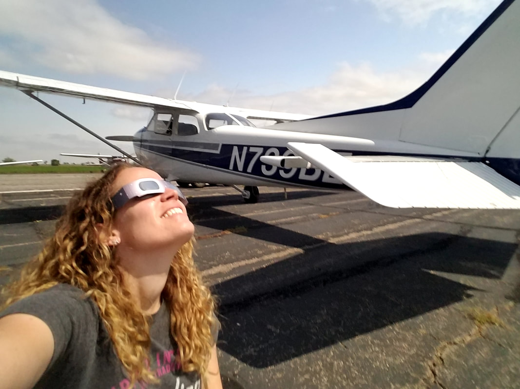 Can’t view it in person? Live coverage is often available on NASA TV and the agency’s website. FMI, visit https://solarsystem.nasa.gov/eclipses
Plan ahead! Fly safe, fly often!
0 Comments
Fall is upon us and, with that, come corn mazes amongst other things! Let’s talk about some of the awesome things we, pilots, have the privilege to see from the air! I have to start with the Amelia Earhart earthworks outside of her hometown of Atchison, Kansas. This beautiful 42,000 sq ft art site was created by Stan Herd in 1997. It was constructed with a viewing deck on a hillside overlooking Warnick Lake. Coordinates to punch on the GPS: 39°32'15.5"N 95°08'42.6"W. 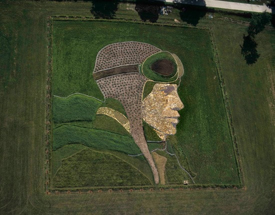 USA Today asks readers for their top 20 corn mazes every year and then 10 of them are selected for the “Best Corn Maze” award. This year, these are the top 10:
 Photo Credit: Cornbelly’s Like corn mazes, the design of some of the best gardens around the world is best observed from the air. One of my favorites in the U.S. is the Biltmore’s in Asheville, NC. Coordinates: 35°32'25.5"N 82°33'05.6"W.  Architecture is often looked at from a frontal/side angle but many of the old architecture is best admired from the top. I’m using the Ciudadela de (or Cidatel of) Jaca in my beloved Spain as a good example of this. In addition to being a military fortress, it was also used as a prison. The fortress has a five-pointed starry plan and is preserved practically intact since its construction. Coordinates: 42°34'20.9"N 0°33'08.2"W. 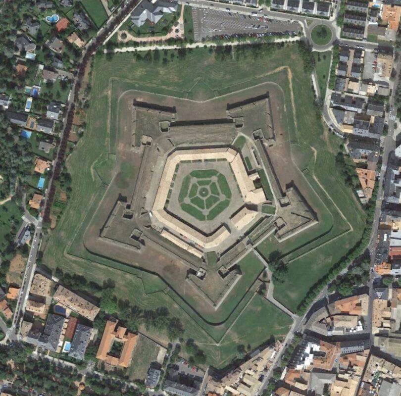 Photo Credit: Google Earth But, if you’ve read many/any of my prior articles, you know National Parks are some of my favorite places to visit and enjoy. So, with that in mind, I can’t leave a magical place like Yellowstone out of this list. Grand Prismatic Spring is honestly best seen from the air but plan any possible emergency near it wisely, just in case… bubbles and burning water! Coordinates: 44°31'30.2"N 110°50'17.5"W. 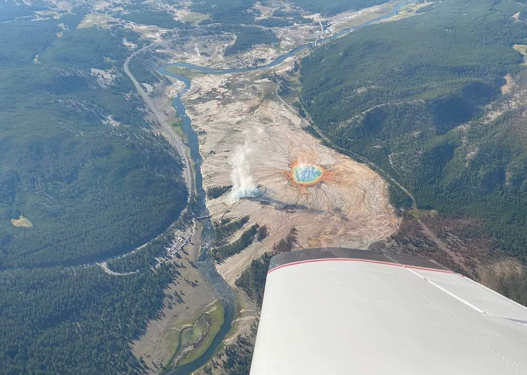 If you can’t fly over it, the second best place to see it from is the overlook adjacent to it. However, it requires a short walk from the Fairy Falls parking lot. Keep in mind it is hard to see it in the winter, as we learned last February when we visited. The air is so cold and the water is so hot that a cloud of steam is created, making it difficult to see the eye of the spring. 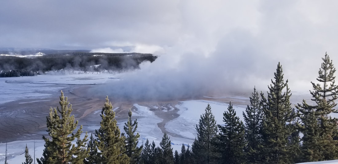 Another unique site that can only be seen once a year is Nevada’s Black Rock City, where tens of thousands of people gather to celebrate Burning Man. The metropolis, dedicated to community, art, self-expression, and self-reliance, continues to grow year after year and, eventually, it will complete the full circle. Coordinates: 40°47'11.0"N 119°12'23.4"W. 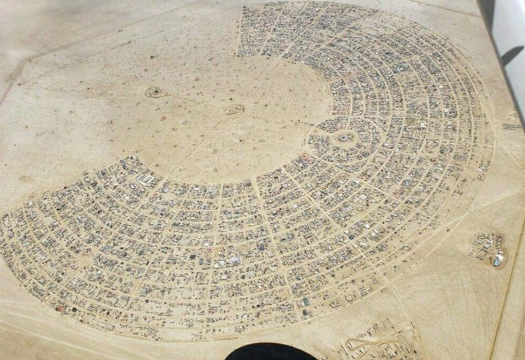 I’ll end with the most unique place I’ve ever seen from the air: Peru’s Nazca Lines. The Nazca Lines are a collection of giant geoglyphs (designs or motifs etched into the ground) created by the ancient Nazca culture (which began around 100 B.C. and flourished from A.D. 1 to 700). These lines (some of which are 30 miles long), geometric designs, and pictorial representations (which can measure up to 1,200 feet) were designated a UNESCO World Heritage Site in 1994 and are still a mystery to researchers despite having been studied for over 80 years. If you don’t take to the skies, you can’t really see them! Giving you only one coordinate does not do this large area justice, but here are the coordinates for the tree in the provided picture to get you started: 14°41'37.6"S 75°06'51.9"W. For more information, you can take a look at this other blog I wrote a couple of years ago. 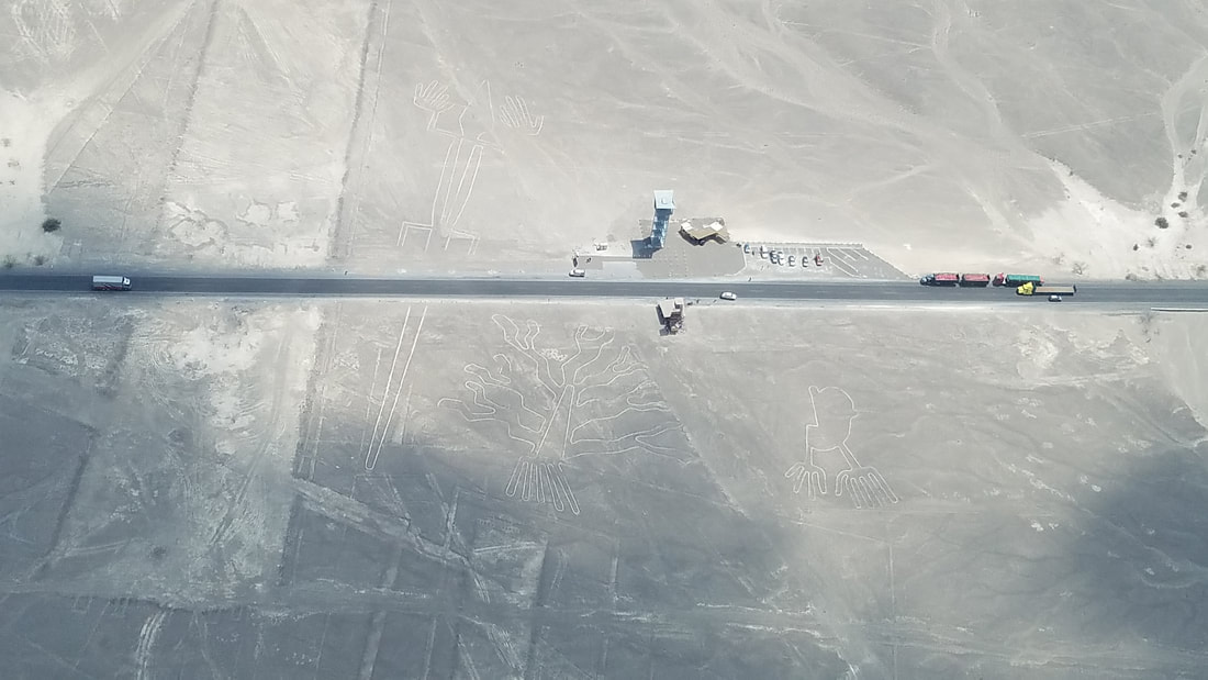 Fly safe and fly often! Have you flown over any of this year’s Top 10 Corn Mazes? Send me a note with some of your favorite places to see from the air.
(As a relevant side note, this article/video from AOPA highlights a farm in Washington State pilots can fly into, picnic, pick their own pumpkins, etc: Pumpkin run) Traveling during a pandemic has proven to be risky and, therefore, undesirable for many. RV travel trends have increased because people are not only transiting in their own vehicle but also staying (eating, sleeping, showering…) in their own house on wheels, with their own stuff. Flying General Aviation (GA) though (especially if you own your own aircraft) is also a great Covid-friendly way to travel, especially for day trips. This blog highlights a few airport lodging options and resources you may want to consider, now and in the future, during overnight trips; however, the list is not exhaustive.
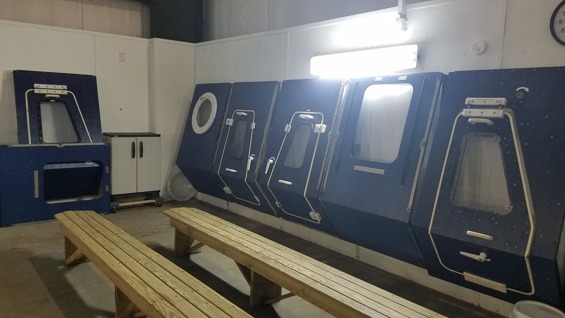
New York’s Drop Inn B&B is not called that for no reason. This cute log house is located at the Shear Airport (63NY). With prior permission from the owners, you can fly into their 3,153-foot grass strip, skydive (get the “drop inn” reference now?), visit the Niagara Falls, and try out wineries among other things. If peace and quiet is what you’re looking for… West Virginia’s Hales Landing Airport (2WV3) has a 3,100-foot grass runway and an Airbnb. Ask the owners for permission to land when booking the stay. During your next trip to Texas’ Big Bend country, you can consider booking one of Casa de Aero’s Airbnb listings in Terlingua. With their permission, you can fly into Fulcher Field (3TE8) with a 3,600-foot gravel runway. The owners can provide you with rental car information for your stay. Or, if you prefer to tent camp, Big Bend Ranch State Park Airport (3T9) lets you fly into their 5,500-foot paved airstrip and camp under your wing/rotor. The state-owned airport offers complimentary transportation to and from their park. Call ahead (432-358-4444, ext. 224) for more information and to let park staff know when you will arrive. Because of its decorations, you may travel all over the world without leaving your Airbnb at the Yucca Valley Airport (L22) in California. This may be my favorite option in this list though it comes at a price. Not only because it is gorgeous and because it has great views of the surrounding mountains but also because it is in a central location to Palm Springs, Joshua Tree National Park, and Big Bear, for example. You can find Lake Lawn Airport (C59) and Lake Lawn Resort due south from Oshkosh, WI. Runway 18/36 is 4,423 ft long; however, look for trees, powerlines, and fences on both ends and keep in mind the asphalt may have cracks with vegetation growing with it. The resort is across the street from the airport. Swimming, golfing, boating, kayaking or paddle boarding are all Covid-friendly activities you can embark on while there; however, you will face more interaction with other guests and staff while inside the hotel. Similarly, flying into the Nemacolin Airport (PA88) in Pennsylvania and staying at their Nemacolin Resort is, without a doubt, the most luxurious option on this list. Obtain prior permission to fly in (recommend at least a 48-hour lead-time) and go pamper yourself! On the other corner of Pennsylvania and much more outdoorsy, though still romantic, is an Airbnb at the Cherry Ridge Airport (N30). Though this is a privately-owned airport, it is publicly used. It has a 2,986-foot asphalt runway and you can park your aircraft immediately in front of the house. If you're willing and able or looking to spend a month away, Summerland Key Cove Airport (FD51) in the Florida Keys is a great option. It's one my husband Jared and I experienced a few years back and blogged about. Runway 12/30 is decently long (2,550 ft but with two displaced thresholds) but quite narrow (20 ft) as compared to most runways. There are a few rental options onsite but this VRBO is the one we stayed at and highly recommend. Remember to get permission to land when you book and pay attention to the restricted area just NW of the field. Do your due diligence as a PIC before each flight. For example, keep in mind most of these airports/airstrips do not offer fuel and may not have lights for night flying. The blog "Friendly Airports and Helipads in the Central Southwest Region" also has an Excel listing of friendly airports and helipads with on-site camping, on-site restaurants, on-site museums, bike lanes nearby, and places to watch aircraft come and go in the Central Southwest area of the country. You may also want to join the fairly new Facebook group called “Pilot friend Airbnb” for additional offerings. Fly safe and fly often! AVIATION SURVIVAL and egress training: Training I Hope I Never Need to Use but Glad I Experienced9/26/2019 I recently participated in Survival Systems USA’s Aviation Survival and Egress Training (ASET) 3 course where we learned how to survive an unsuccessful water landing. In their words, the “accelerated program addressed the risks associated with frequent travel over or near water by providing pilots, aircrew, and passengers with pre-flight, in-flight, and post aircraft ditching knowledge and survival skills including use of Emergency Breathing Devices (EBDs).” FMI: https://www.survivalsystemsinc.com/aviation-survival-egress-training.html. While we could not film or take pictures during training because we had a VIP in our class, you can watch a summary video of some of what we did on their website.  “Ditching, ditching, ditching…” is what I heard all night for a few nights after the class as I was dreaming about all the scenarios and procedures we had performed. My fellow scholarship receipt and roommate, told me I even talked in my sleep the night after the training. It was nothing like watching Bear Grylls while sitting on a couch in the comfort of my own home… It was one of those “once in a lifetime” experiences (best with some recurrent training to keep the skills fresh) you hope you never actually need to use. But one is better off with the training than without it! We had roughly four hours of ground and four hours of pool practice. During ground, the instructor taught us some physiology concepts and we discussed everything we were going to do in the pool, learned best techniques for bracing, went through procedures and tips for exiting the aircraft, heard about lessons learned from their ongoing research and development (such as breathing techniques, clearing techniques, or disorientation), talked about survival equipment, etc. During the second portion, after passing a written exam, we did a number of “dunking” runs with different:
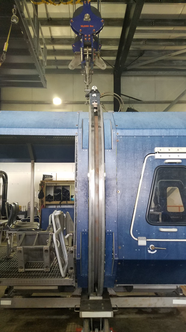
 We did them in the training chair (Shallow Water Egress Trainer or SWET, as they call it) first and then moved to the Modular Egress Training Simulator (METS). We did them exiting through our closest exit first and then simulating our closest exit was not available (locked, jammed, etc) and had to go across the aircraft to another exit. We did them holding our breath first and then did the more difficult ones with compressed air as well.
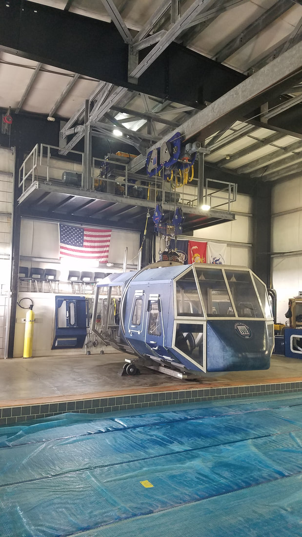
Additionally, they showed us what a life raft usually comes with, how to open it, how to get in and out of it based on the number of people available, etc. and how to get hoisted out of a helicopter using a basket and a winch with a harness. 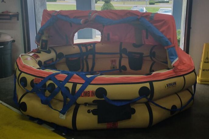 The excitement never stopped. The table in the file below describes some of the preconceptions I had going into the training and what I actually found:
And that’s all because you don’t know what you don’t know… or what we make up or imagine what we don’t know… I’m not sure which is worse! The most important things that I learned or that refreshed my memory are:
These were the basic procedures I followed during every submersion:
And, believe it or not, AFTER ALL THAT… we still had smiles. 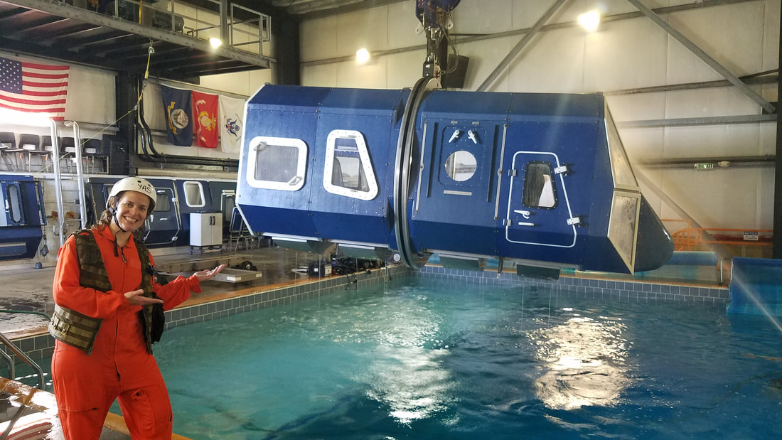 This training was honestly invaluable. I highly recommend everybody (especially seaplane pilots and those flying over open/large bodies of water) take it. I not only learned about all the different things that the class was meant for but I also learned about myself and overcame some fears. I am confident that I am now more likely to survive an otherwise unlikely and very unfortunate accident.
Before I close, I want to give BIG props to the Whirly-Girls and Survival Systems for giving me the opportunity to take this training by way of a scholarship and for just simply being amazing. The Whirly-Girls is the best organization I belong to and the Survival Systems facility, instructors, safety divers, etc were seriously impressive. The instructors were with us during our every move: teaching us, watching us, giving us feedback, making sure we were ok, and putting up with our runny noses. They even had time to re-buckle our seatbelts after we got out, even on those exercises we did without compressed air. I can’t get over that! You know the phrase… “a pilot is always learning” and, as my dad would say, knowledge doesn’t occupy space; it’s the best investment one can make. What’s your next training going to be? Survival? Flight review? High altitude chamber? Another rating (an instrument rating is especially good!)? A higher certificate? Written by the author, Yasmina Platt. Reprint from September 12, 2012, from AOPA's Views From the Region (VFR) blog (https://blog.aopa.org/aopa/author/yplatt/page/5/) but updated multiple times since. Yasmina Platt, AOPA’s Central Southwest Regional Manager, takes NASA’s Physiological Training, including the high altitude chamber and rapid decompression exercises, and shares her experience and highlights. I have been trying to take NASA’s Physiological Training (a.k.a. high altitude chamber training) for several years now, but it wasn’t until High Performance Aviation, LLC scheduled it as an FAA Wings safety seminar that I was able to sign up. For those who might be unaware, NASA’s *free* Physiological Training covers the physiological stresses of flight. More specifically, it teaches attendees about gas laws, hypoxia, hyperventilation, trapped gas, decompression sickness, spatial disorientation, cabin pressurization, and oxygen equipment in addition to exposing participants to high altitude chamber and rapid decompression exercises. Early this morning, on September 11, 2012, my husband (also a pilot) and I arrived at NASA’s Sonny Carter Training Facility at the Johnson Space Center in Houston. 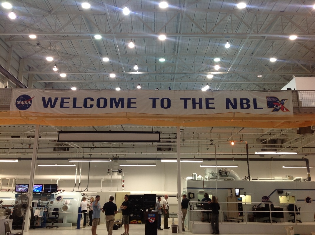 From 7:45 am until about 2 pm, all nine of us in the class received ground school from NASA experts. While we covered a lot of different physiological subjects, this blog will focus on hypoxia as it was the main topic of the seminar. Below I share some of the highlights I learned from the class (or refreshed in class but think are important points): – Air is composed of 78% nitrogen, 21% oxygen, 0.03% carbon dioxide and 0.97% trace gases. – Hypoxia is a state of oxygen deficiency (not lack of oxygen) in the blood, tissues, and cells sufficient to cause an impairment of mental and physical functions. – Hypoxic signs are objective and, therefore, they can be seen by others. They include: increased rate and depth of breathing, cyanosis, slurring of speech, poor coordination, mental confusion, euphoria, belligerence, lethargic, and unconsciousness. – Hypoxic symptoms are subjective sensations that only the person who is hypoxic can detect. These include: blurred vision, euphoria, nausea, tunnel vision, numbness, dizziness, air hunger, tingling, fatigue, hot and cold flashes, apprehension, headache, and belligerence. – Although the percentage of oxygen contained in the air at 18,000 feet is identical to that at sea level (a little over 20%), the amount of air our lungs take in with each breath contains half the oxygen found at sea level. – Respiration determines how well we function in flight. At 5,000 feet, we start to suffer hypoxia. Above 10,000 feet, the pO2 is too low to support life. This is different from the FAA’s 12,500 feet supplemental oxygen rule. Refer to 14 CFR Part 91.211 if you want to refresh your memory. – The most dangerous feature of hypoxia is its insidious onset, a situation that comes on slowly, without obvious symptoms at first so the person is not aware of its development. – If you ever experience any of the flight physiological sicknesses, it is recommended that you visit a flight medicine doctor (or diving doctor). After lunch, we were assigned oxygen equipment composed of a helmet, a pressure demand mask and a few connectors. Then it was time for the NASA hypobaric (high altitude) chamber, the same one used for astronaut training. Cool!! We are going to play astronaut for a day! =) The high altitude chamber and rapid decompression exercises we participated in are designed to enable people to identify their own symptoms to hypoxia while inflight 1) in an unpressurized aircraft without oxygen or 2) in a pressurized aircraft and cabin pressurization is lost. Let’s talk about the first exercise first… the high altitude chamber (see picture below). Once we were all assigned a seat, we breathed 100% aviator oxygen for 30 minutes to eliminate about 30% of the nitrogen out of our systems (remember the air composition explained above). At that point, the air inside the chamber was released, taking all of nine of us plus two instructors (several others, including a flight surgeon, monitored us from outside) to 25,000 feet at a fast 5,000 foot a minute rate. Once stabilized at 25,000 feet, we all removed our oxygen masks (in two different groups). At 25,000 feet, there is only about 1/3 of the amount of oxygen found at sea level. Needless is to say that it only took us a few minutes before we started to notice hypoxic symptoms/signs. It only took a couple of minutes for some and others were able to stay off the oxygen for about 4 minutes or longer. We were told to last as long as we could but to don our masks when we felt we needed to, knowing that everybody had to have oxygen back on at minute 5 to avoid unconsciousness. It was interesting to see how different people reacted to hypoxia in different ways, which is what makes this training so important. Most of us pilots know the “typical” symptoms of hypoxia; however, none of us know how our body reacts to hypoxia until we are exposed to it. It is also important to note that most people will experience hypoxic signs and symptoms in different orders. While some might start by feeling dizzy, others might start with a blurred vision, for example.  Another important thing we learned in class is that a typical person has a blood oxygen saturation (the blood’s ability to carry oxygen) of 98% at sea level while that percentage goes down to 87% at 10,000 feet. This was verified by one of the class participants by using an oxygen sensor in one of his fingers. As soon as we leveled off at 25,000 feet and he took his mask off, his percentage went down to 86-87%. Then it continued decreasing to about 81% before he had to put his oxygen mask back on. I am going to quote one of the instructors in describing how people feel or look when they are experiencing hypoxia: “Lights are on, but no one is home” and “the pistons were not firing well.” My personal feelings/signs/symptoms during the exercise were the following: (and, yes, we wrote them down during the exercise and answered a few basic questions – not so basic when you are oxygen deprived though) – Minute one: Feeling ok. – Minute two: Feeling ok but started getting a little dizzy. – Minute three: Feeling ok but started getting really hot and my dizziness continued. – Minute four: Still really hot and my legs started to tingle. – My vision was pretty clear the entire time and so was my thinking/brain from what I could tell. I was able to complete the exercises without too much trouble; however, it does take more effort to concentrate (and this might prevent you from doing other tasks at the same time). Remember “insidious onset”? Yes, it is very difficult to know when you are getting hypoxic and, worse yet, when you are really “losing it.” Hypoxia doesn’t give much warning. The last exercise of the day was the rapid (1 to 10 seconds) cabin decompression. In groups of two or three, we each experienced what all flight attendants demonstrate on commercial airliners when they simulate the oxygen masks dropping from the overhead. I never questioned the fact that they want us to “wear our masks first before assisting others;” however, I learned exactly why during this exercise. If you don’t have enough oxygen yourself, you can’t function and, therefore, you can’t help anybody, causing you and the other person to quickly become hypoxic. Some of the indications of a rapid decompression include explosive noise, windblast/flying debris, fogging (we certainly saw that!), temperature drop and pressure. I am very glad I now know the hypoxia symptoms I (again, different from what others might experience) could experience inflight, how to recognize them and when to take action before it’s too late. Should I have experienced hypoxia in an aircraft (rather than in a chamber) for the first time, there is no doubt in my mind I would have passed out, become unconsciousness and potentially passed away. My main two symptoms were hot flashes and leg tingling. How many times do we feel hot (and sweat) in an non-air conditioned aircraft? Many times… so I would have just opened or turned the air vent towards me a bit more. And the leg tingling… well, this happens to me sometimes so I wouldn’t have thought too much about it. Pilots (and passengers) have seconds (in the case of the rapid decompression) or just a few minutes to recognize their symptoms before putting their masks on or risking becoming unconscious. After going through this training, my personal altitude limitation without appropriate oxygen will be 10,000 feet regardless of the FAA’s conservative supplemental oxygen regulation. We all found the training to be invaluable for pilots and I wish more pilots got a chance to take it. I want to thank B.R. with High Performance Aviation, LLC for his initiative and work in scheduling several different classes to accommodate a total of 75 pilots who registered to undergo this training. I also want to thank the wonderful staff at NASA’s Human Test Support Group for their dedication and for sharing their knowledge with us. Some of the instructors involved included S.C., J.R., S.S., R.W., B.G., B.B. I am protecting their identity by only sharing their initials. The instructors were even nice enough to show us NASA’s Neutral Buoyancy Lab (NBL), a majestic 202’ long x 102’ wide x 40’ deep pool with 6.2 million gallons of water where astronauts train their spacewalks in the closest environment to weightlessness. The pool had full scale replicas (although not entirely attached due to its large size) of parts of the International Space Station. 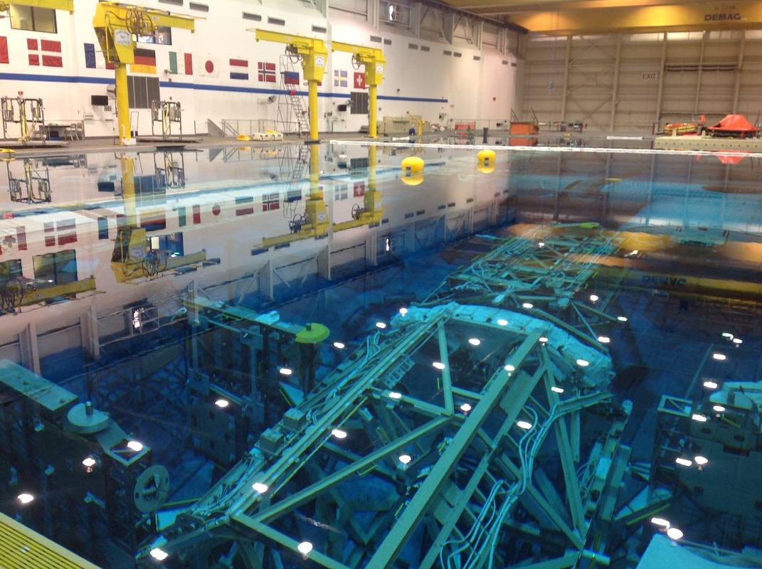  Just remember what one of the instructors told us “If you can breathe, you can think; if you can breathe, you can perform; and if you can perform, you can survive” and keep that in mind as you fly along… and, if you ever have a chance to take this training, DO IT! You’ll be happy you did…
I'm going to start to compile other people's interesting travel blogs here. Let's start with the website/magazine Pilot Getaways and a few blogs from General Aviation News:
- A new pilot's first flying vacation, about a trip from Greenville, SC to Nashville, TN, Indianapolis, IN, and Dillard, GA. - 72 hours in Phoenix, with a side trip to Sedona, AZ. - An Alaska Logbook: Excursions to Chena Hot Springs and Talkeetna, close to Fairbanks and Denali. And now from other sources: - Flying high by Alan Malone, about flying in the mountains and high elevation areas - The Boulder Milk Run by Alan Malone, about a trip from New Orleans, LA to Boulder, CO and back AOPA also has a "Destinations" section in their web page: https://www.aopa.org/destinations/ Feel free to send me other suggestions via the "About and Contact" page and I'll be happy to add them! As we approach the longest holiday season of the year… I got to thinking “what do holidays (and other things we celebrate) and flying have in common?” Yes, we can be thankful to live in the best country for GA flying ;) Yes, we have more time off to fly! =) Yes, we can ask Santa for that awesome headset we’ve been wanting :) What else? Does it help you if I show you this collage?  Uh huh! Several of the holiday “symbols” or “characters” fly =) Pretty awesome, right? Or maybe I’m just easily excited? That could be but I think it’s pretty cool that even holiday characters want to fly instead of doing anything else or using any other type of transportation. Why is that? Why do they fly? Where they invented before or after the Wright Brothers’ first flight? Were their creators visionaries? Well, I researched Halloween, the stork story, Santa, and the tooth fairy to see if I could find some answers:
Even 4th of July is normally associated with military jets, fly overs, freedom (and what better freedom do we have than being able to fly ourselves!), and other flying things (like rockets and fireworks).  Well, we know the Wright Brothers successfully piloted their first powered airplane in 1903. So, some of these characters were flying before it was even a feasible activity for our ancestors. Maybe their creators (like Santa's) were, in fact, visionaries; however, some of them are animals that can fly on their own power and witches could theoretically fly because of their "witch powers" and the hallucinogens they made and took.
But why did the creators choose animals that could fly versus animals that could not fly, for example? What made flying animals special? I really think it's because flying is magical. Human kind has been fascinated with flying for centuries. Let’s keep it that way! Happy holidays! I have fallen in love all over again… I have learned to fly all over again… Flying helicopters has been the perfect combination of art and Science, Technology, Engineering, and Math (STEM). I would say STEM is what gets them in the air but art is what keeps them flying. Many of you have asked me to document my airplane to helicopter transition so here I am… What Does Helicopter Flying Feel Like? “Open air art exhibit.” “For the privileged view.” “It’s cool when the weather is hot and nice and warm when it is freezing outside.” “A cramped booth, UV bulbs, funny googles.” “Let the outside in.” “Work in a cubicle?” “Stay spontaneous.” “Dollar for dollar.” “Be the first to know it’s raining.” “Youth, beauty, action.” What do you think all those quotes are? Well, they are marketing slogans from convertible ads! But it’s funny how they can apply to flying Robinsons too. They really feel like low-to-the-ground sporty convertibles with fantastic visibility, maneuverability, and versatility. At least that has been my experience. And who doesn’t like convertibles? You know what else it feels like? This:  Haha. No, seriously! It’s hard to come up with a favorite helicopter maneuver; however, I really enjoy those things I can’t do in an airplane. For example, pirouettes (flying in one direction, at hover altitude, while rotating around oneself) – challenging but lots of fun. Quick stops because you go from a take-off or cruise configuration to a combo between the beginning of an autorotation and the end of a steep approach. And, for a while, I just wanted to do autos (or autorotations, simulated engine outs) as normal approaches. There’s something about dropping 600-800 feet in just seconds that I find amusing. Differences between Fixed-Wing and Rotor-Wing Flying The differences between airplane and helicopter flying are immense. So much so that it does not feel like “just an add-on” or transition training; it feels like learning to fly all over again. I only found a few things transfer or are helpful when transitioning to helicopters:
The rest is pretty much different:
Below, I will explain some of those items. Lesson #1 Helicopter pilots have both of their hands (and feet) pretty occupied at all times but certainly around the airport environment (and especially when taxiing or maneuvering low to the ground). During my first or second lesson… I was (assisted by my CFI) practicing hovering, pedal turns (turning around the CG, without moving forward, backwards, or to either side), etc up and down a taxiway when an airplane turned towards us. We immediately got out of the way and hovered parallel to it, over the grass, letting the airplane taxi past us. The pilot of the airplane waved at us to say hi! Lesson #1 (for me, anyway): Helicopter pilots are not rude if they don’t wave back. They just may not be able to ;) Their left hand is on the collective, the right one is on the cyclic, and cannot let go! Lesson #2 Yes, helicopters are incredibly capable but I was surprised to learn all their limitations and things you can do but you want to minimize doing (i.e. the height-velocity diagram in the R-22). I mean, really surprised. There’s a lot to take into consideration. They are not quite as “superman” as I thought… Cross-country Lesson #1 I also would have never thought changing frequencies would become one of the hardest things to do but I initially found it to be that way. Why? Well, similar to lesson #1. Autopilots in helicopters are extremely expensive so not that many of them have them. Even though some helicopters (like Robinsons) have trims, they are not like airplane trims where, once you set it, the airplane will stay pretty stable and you can let go for a while before a correction is needed. You literally can’t let go of the cyclic (right hand) and some helicopters (like the one I flew during my cross countries) have pretty sensitive collectives (left hand), making it hard to let go of it in order to change frequencies, look at charts, etc. I learned that the only safe way to do it was to temporarily set the collective’s friction lock to keep it from lowering immediately. And I say temporarily because you don’t want to fly around with your friction lock on all the time. If you need to execute an auto, one of the first things you do is lower the collective all the way down. You don’t want the lock to prevent you from being able to do that. Not to mention you also need to raise the collective at the bottom of the auto to cushion the touchdown. Oh and how in the world did people fly, without doors, and paper charts in helicopters just a few years ago? Phew! How did they manage to flip it to the right area? I want to bow to them. Thanks, ForeFlight, for making my life a lot easier! Aerodynamics/Limitations The word “helicopter” is linked to the Greek words “helix/helikos” which means “spiral” or “turning” and “pteron” which means “wing.” The four principles of flight apply to both types of aircraft; however, helicopters have a long list of additional aerodynamic principles, limitations and other things to be aware of that we do not study in “airplane training.” Some of those include:
I am not explaining them because I could write an entire blog about each of those separately. If you are interested in reading about them, take a look at the FAA’s Helicopter Flying Handbook. You can find it, for free, here. Thank you, Leonardo da Vinci, Juan de la Cierva y Codorniu and Igor Sikorsky, for all your hard work. You had a LOT to overcome. Speed I don’t mean the speed in which you need to react to situations. That is definitely much faster in a helicopter than in an airplane. I mean indicated airspeed! While going slow in an airplane is frowned upon (rightfully so because of stalls/spins unless you are in a STOL capable aircraft), it’s one of the most beautiful things in helicopters. But, I’m not going to lie, the transition from seeing the airspeed indicator go from an approach speed of about 60 kts in a small GA plane to close to 0 kts for a steep approach in a helicopter raised up my blood pressure a bit at first. Flying Solo vs Flying Dual I see no real Center of Gravity (CG) difference between flying an airplane solo vs flying one with another CFI or passenger. But, woah, that’s not the case in a helicopter. It is way different! As a helicopter student flying a R-22 (and maybe because of my airplane experience), I had no idea how different it would be to fly solo until I actually did it for myself. Yeah, I had read all about it, I remembered my CFIs talking about it, and I had seen it for myself in the CG/weight and balance calculations/graphics. But there’s just nothing like experiencing it for yourself. With both seats occupied, the helicopter is pretty balanced (both laterally and longitudinally). However, when you remove the left seat weight, it is no longer balanced and pilot inputs need to counteract the difference in acting behavior (especially as fuel is getting burned and the CG moves forward). With CFI/Passenger: 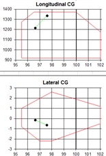 Alone: 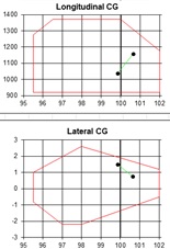 Here’s exactly what I noticed when flying the R-22 by myself:
It also means less weight = less power needed = more power available. In airplanes, we always take off with full power and we always pretty much use the same RPM/MP setting in cruise. However, in helicopters, the power used/necessary (different for takeoff, hovering, and cruise) depends on that day’s temperature and density altitude. When flying close to max weight, you could be exceeding those power settings or just not able to fly or do certain operations/maneuvers (like hovering, for example) at all. Emergencies and Hazards I can understand why most dual rated pilots won't fly both types of aircraft on the same day now. They are so incredibly different! The question is not whether or not a person can fly both safely in normal conditions but whether that person will react to an emergency correctly should one occur. All aircraft have different systems and work slightly different but, in an emergency, these contrasts could cause a pilot to confuse one for the other and the brain/reflexes may not react correctly. For example, a stall warning horn in an airplane sounds very much like a low RPM warning horn in a helicopter. Recovering from what may sound like a "stall warning horn" in a helicopter could result in a fatal accident. What is the first thing you do in an airplane when recovering from an aerodynamic stall? Fairly aggressively lower the nose, right? Well, two things in a helicopter:
Also… if you lose the engine in an airplane, you don’t pay attention to RPMs, just airspeed. However, if you lose the engine in a helicopter, controlling rotor RPM (and airspeed although in a second place), again, means life! It may sound simple, you may wonder how the heck that could happen to people but history proves that brains can do funny things when faced with quick, out of the ordinary, and stressful situations. And none of us are immune to it. Add-On Training and Certification Like with airplane training, you have two routes to choose from: Part 61 and Part 141. If you are a commercial airplane pilot like me, you can also choose between obtaining a private add-on or a commercial add-on. I chose Part 61 because, when I started, there was only one flight school around and they were not 141 approved. I also chose to start with the private add-on option for two reasons: cost and PIC time needed. I will not go into more detail here since you essentially have four different options. Just take a look at the regulations yourself and consult a local CFI/examiner/FSDO if you have questions. Different people/FSDOs may interpret the “add-on” part differently. For example, Part 61’s helicopter section for private pilot certificates states you essentially need 40 hours total time, of which 20 need to be dual and 10 need to be solo (BTW – the FAA’s SFAR 73 also says you need to have 20 hrs dual before you can solo). Most schools interpret it to only be 30 hrs total time for helicopter add-ons; the total time only applies to initial certificates. However, I personally do not read it that way and neither does the FSDO/examiner/CFIs I checked with. But, honestly, I would not get to hung up on it because, truthfully, most people (initial or add-on) cannot finish it with less than 40 hrs anyway. I had 43 hours before I took my checkride and I really could not have done it much quicker than that. Learning to fly a helicopter is not like learning to fly a seaplane. Keep in mind a seaplane is just another class; helicopters are an entirely different category. Conclusion There is no question helicopters are far more expensive, versatile, and challenging than airplanes but nothing worthwhile comes easy in life. So, have you been thinking about helicopter training? “Nobody can go back and start a new beginning, but anyone can start today and make a new ending.” – Maria Robinson (fitting enough!) I’m going to continue on to obtain a commercial certificate when funds allow. 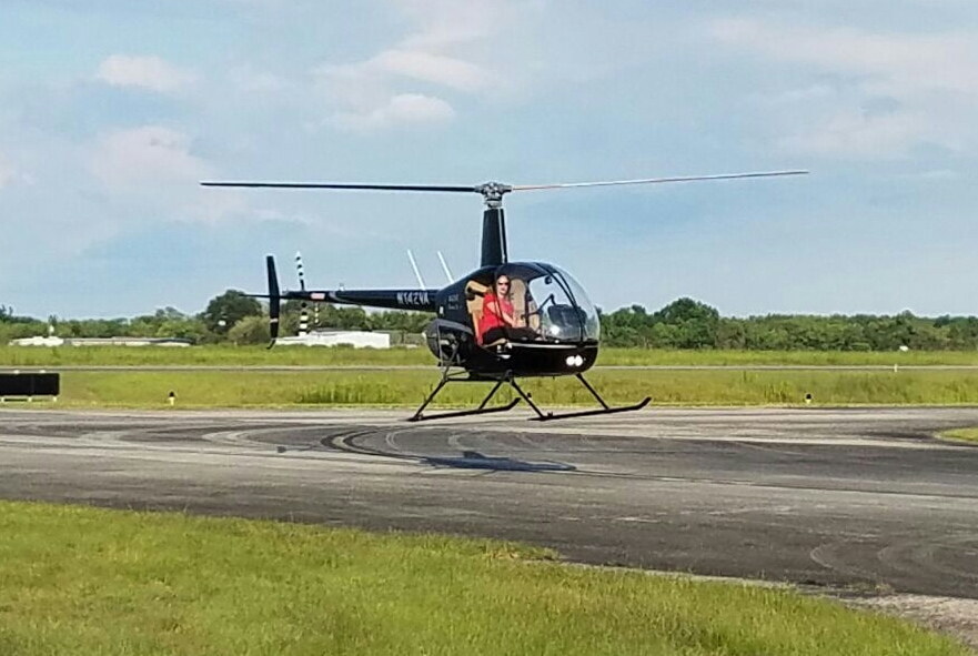 (Special thanks go out to The Whirly-Girls for selecting me as their 2016 WG Helicopter Add-on Flight Training Scholarship recipient)
Written by the author, Yasmina Platt.
Reprint from August 13, 2013, from AOPA's Views From the Region (VFR) blog: https://blog.aopa.org/vfr/?p=794 One of the things we are trying to do here at AOPA is to increase recreational flying. We can do so by opening up more airstrips, preventing airstrips and airports from closing, engaging in fly-ins and other flying events, introducing new people to general aviation, etc.; however, we can also increase recreational flying by increasing visitation to some of the nation’s most beautiful spots… the U.S. National Park Service system via its airports. While at EAA’s AirVenture in Oshkosh this year, I attended a great seminar about “flying to national parks” and I wanted to share some of my notes with all of you. The seminar was taught by Cliff Chetwin, retired Park Ranger and Park Service pilot for the National Park Service. The U.S. National Park Service (NPS) was created in 1916 “…to conserve the scenery and the natural and historic objects and the wild life therein and to provide for the enjoyment…by such means as will leave them unimpaired for the enjoyment of future generations.” NPS has approximately 401 national park units with over 30 designations, including parks, forests, primitive areas, wilderness areas, recreational areas, national seashores, national monuments, national lakeshores, and national wildlife refuge and range areas. For more information about the Aviation unit within NPS, visit http://www.nps.gov/fire/aviation/ Flying into these magnificent sites and parks is one of the least invasive and most enjoyable ways to get to the parks; however, it does require “careful planning and consideration.” Careful planning includes all of the normal cross country planning tasks (checking weather, planning a route, looking for alternates and alternatives, etc.) plus ensuring you and your aircraft are capable of operating at the intended airport. Some of these airports are surrounded by mountains, at high elevations, at high density altitudes, etc. and some only have gravel or grass strips with rising or descending terrain. If you need to bring a CFI with you, do it! It is also a good idea to contact the airport prior to departure to ensure you will have transportation upon arrival and that they will have fuel for you, if needed. Some of these strips are pretty remote and getting fuel can take time (sometimes days or weeks). And, while you are at it, ask the airport manager for any arrival/departure tips he/she might have as a local. Consideration refers to remembering that you are flying into a site designated as a national treasure (regardless of whether it is a national park or a historic site) and that people and animals are there to enjoy peacefulness among other things. You are flying into a noise sensitive area and, as such, Mr. Chetwin recommended following “14 noise rules” as best as possible while remaining safe and using good judgment in addition to reading any specific noise abatement procedures for the particular airport you are flying to:
FAA Advisory Circular (AC) 91-36D (VFR Flight over Sensitive Noise Areas) also encourages pilots making VFR flights near noise-sensitive areas to fly at altitudes higher than the minimum permitted by regulation and on flight paths, which will reduce aircraft noise in such area. This AC can be found athttp://www.faa.gov/regulations_policies/advisory_circulars/index.cfm/go/document.information/documentID/23156. You should, of course, also watch for wildlife on airport grounds. Aeronautical Information Manual (AIM) 7-4-6, “Flights Over Charted U.S. Wildlife Refuges, Parks, and Forest Service Areas” (http://www.faa.gov/air_traffic/publications/atpubs/aim/aim0704.html) reads, in part: “Pilots are requested to maintain a minimum altitude of 2,000 feet above the surface of the following: National Parks, Monuments, Seashores, Lakeshores, Recreation Areas and Scenic Riverways administered by the National Park Service, National Wildlife Refuges, Big Game Refuges, Game Ranges and Wildlife Ranges administered by the U.S. Fish and Wildlife Service, and Wilderness and Primitive areas administered by the U.S. Forest Service.” AC 91-36D mentioned earlier also defines the surface of a NPS area as the highest terrain within 2,000 feet laterally of the route of flight, or the upper‐most rim of a canyon or valley. Simply stated, find the highest ground on your flight path and add 2,000 feet to your cruising altitude over these parks: – Acadia – Alibates Flint Quarries – Amistad – Aniakchak – Apostle Islands – Arches – Arkansas Post – Assateague Island – Badlands – Bandelier – Bering Land Bridge – Big Bend – Big Cypress – Bighorn Canyon – Big South Fork – Big Thicket – Biscayne – Black Canyon of the Gunnison – Bryce Canyon – Canyon de Chelly – Canyonlands – Cape Cod – Cape Hatteras – Cape Krusentern – Cape Lookout – Capital Reef – Capulin Volcano – Carlsbad Caverns – Cedar Breaks – Chaco Culture – Channel Islands – Chiricahua – Colorado – Coulee Dam – Crater Lake – Craters of the Moon – Cumberland Gap – Curecanti – Death Valley – Delaware Water Gap – Denali – Devil’s Tower – Dinosaur – Dry Tortugas – Everglades – Fire Island – Florissant Fossil Beds – Fort Laramie – Fort Point – Fort Union – Fossil Butte – Gates of the Arctic – Gateway – Gettysburg – Gila Cliff Dwellings – Glacier Bay – Glacier – Glen Canyon – Golden Gate – Golden Spike – Grand Canyon – Grand Teton – Great Basin – Great Sand Dunes – Guadalupe Mountains – Gulf Islands – Haleakala – Hawaii Volcanoes – Hovenweep – Indiana Dunes – Isle Royale – Jewel Cave – John Day Fossil Beds – Joshua Tree – Kalaupapa – Katmai – Kenai Fjords – Kings Canyon – Kobuk Valley – Lake Chelan – Lake Clark – Lake Mead – Lake Meredith – Lassen Volcanic – Lava Beds – Little Bighorn – Mammath Cave – Mesa Verde – Mount Ranier – Muir Woods – Natural Bridges – Navajo – Noatak – North Cascades – Olympic – Organ Pipe Cactus – Ozark – Padre Island – Petrified Forest – Pictured Rocks – Pinnacles – Point Reyes – Rainbow Bridge – Redwood – Rocky Mountain – Ross Lake – Saguaro – Saint Croix – Sequoia – Shenandoah – Sleeping Bear Dunes – Statue of Liberty – Sunset Crater Volcano – Theodore Roosevelt – Timpanogos Cave – Voyagers – Whiskeytown-Shasta-Trinity – White Sands – Wind Cave – Wrangell-St. Elias – Wupatki – Yellowstone – Yosemite – Yukon-Charley – Zion – Parks charted by some other device So, how do you know which parks have airports and which ones you can fly into? – Check sectionals – Check Airport Facility Directories (AF/D) – Check state aeronautical charts – Call NPS or check http://www.nps.gov/fire/aviation/ – Attend one of the NPS aviation seminars like I did You can fly into any public use airport in or near a park and you can also request written permission from a Park Superintendent. Some of the more known parks with airstrips are: – Big Bend National Park in Texas (3TE3). Private use airport. Permission required prior to landing. – Big Horn Canyon (5UF) in Montana which has great fishing. Winds are normally a problem and there is no fuel on the field. – Cape Cod National Seashore (PVC – Provincetown Municipal) in Massachusetts Death Valley, California: Two airports are available. Death Valley is one of the (if not “the”) hottest places on earth so density altitude is definitely an issue at both airports regardless of its elevation. It is not uncommon to see temperatures over 110 F. While one of the 14 noise rules said to try to fly later in the day to allow convection to lift your noise… flying earlier in the day is actually recommended at Death Valley due to density altitude considerations and safety.
– Ft. Vancouver (VUO – Pearson Field) in Washington State. Be aware of Portland International’s (PDX) Class B airspace close by. – Gates of the Artic (PAKP – Anaktuvuk Pass), Alaska – Glen Canyon, Utah: Two airports are available.
– Kalaupapa (PHLU), by Maui, Hawaii. First Flight Airport (FFA) in North Carolina. A daytime only airport… this is one treasured landmark for pilots, where the Wright Brothers made their first powered flight. AOPA donated a pilot facility in honor of the Wright Brothers’ 100th Anniversary of Powered Flight. FMI about it: http://www.aopa.org/News-and-Video/All-News/2003/October/5/AOPA-donated-Pilot-Facility-opens-at-Wright-Brothers-Memorial – Lake Mead National Recreational Area, Nevada: Three airports are available. A seaplane base is also available.
– Wrangell/St. Elias, Alaska: 68A (seaplane base) and PAWG (airport). – Isle Royale in Lake Superior, Michigan: Two seaplanes bases, one at Rock Harbor and another one at Windigo. – Dry Tortugas, Florida: Because of sensitive resource issues, any individual wishing to fly a private seaplane to the park must have a Special Use Permit (http://www.nps.gov/drto/parkmgmt/specialuse.htm) issued through Everglades National Park. There are no facilities at the Dry Tortugas National Park so all seaplanes must have enough fuel and supplies for a round trip flight. Remember that you can always find more information about specific airports athttp://www.aopa.org/airports/ or on FlyQ (http://www.aopa.org/Flight-Planning/FlyQ). And, with that, let’s do some flight planning and go flying! I look forward to visiting some of these airstrips. Written by the author, Yasmina Platt.
Reprint from August 21, 2013, from AOPA's Views From the Region (VFR) blog: https://blog.aopa.org/vfr/?p=819 AVIATION VOCABULARY in SPANISH General General aviation – Aviación civil/privada Airline – Aerolínea Airplane – Avión Passenger – Pasajero Flight Information Reservation – Reserva Ticket – Billete/Pasaje Flight – Vuelo Number – Número Roundtrip – Ida y vuelta One-way (leaving) – Ida One-way (coming back) – Vuelta Roundtrip ticket – Billete de ida y vuelta Boarding pass – Pasaje de abordo Delayed – Retrasado Cancelled – Cancelado Cancellation – Cancelación Around the Airport Airport – Aeropuerto Terminal – Terminal Departure – Salida Arrival – Llegada Runway – Pista de despegue/aterrizaje (takeoff/landing) Hallway – Pasillo Hold room – Sala de embarque (literally “sala de espera”) Restroom – Baño (also known as “servicio”) Store – Tienda Coffee Shop – Cafetería Restaurant – Restaurante Hangar – Hangar Control tower – Torre de control Segmented circle – Circulo segmentado Wind sock – Manga de viento Waiter/waitress – Camarero/a Controller – Controlador/a (male/female) Mechanic – mecánico Flying To fly – Volar Flying – Volando Domestic – Nacional International – Internacional Takeoff – Despegue Landing – Aterrizaje North – Norte South – Sur East – Este West – Oeste Good weather – Buen tiempo (o buena meteorología) Bad weather – Mal tiempo (o mala meteorología) Turbulence – Turbulencia Traffic pattern – Circuito de transito Entering downwind on a 45 degree angle (traffic pattern) – Entrada Upwind (traffic pattern) – Partida Crosswind (traffic pattern) – Viendo cruzado Downwind (traffic pattern) – Inicial Base (traffic pattern) – Base Final (traffic pattern) – Final Luggage Luggage – Equipaje Baggage – Maletas Carry-on – Maleta/Bolsa de mano Checked luggage – Equipage facturado (o maletas facturadas) Luggage trolley – Carro (de equipaje) Security Security checkpoint – Control de seguridad Security guard – Guardia (de seguridad) Police – Policía Metal detector – Detector de metal In the Aircraft Pilot – Piloto (for both genders) Flight attendant – Azafata/o Take-off – Despegue Landing – Aterrizaje Seat number – Número de asiento Seat belt – Cinturón de seguridad Aisle – Pasillo Luggage compartment – Guarda maletas/equipaje Maintenance problem – Problema de mantenimiento International Flights Immigration – Inmigración Foreign country – País extranjero Duty free – Libre de impuestos Passport – Pasaporte Visa – Visado Dollar/s – Dólar/es U.S. – Estados Unidos (EEUU) Transportation Ground transportation – Transporte terrestre (also known as “transporte de tierra”) Public transit – Transporte público Train – Tren Bus – Autobús (also known as “bus”) Taxi – Taxi Other Hotel – Hotel Water – Agua Food – Comida Wheelchair – Silla de ruedas Public telephone – Teléfono público Cell phone – Móvil (also known as “teléfono celular”) AVIATION PHRASES in SPANISH ¿Cómo se/te llama? (“Se” is more formal than “te” but they both mean the same) What is your name? ¿Cómo le puedo ayudar? How can I help you? ¿Qué necesita? What do you need? Trabajo para el aeropuerto. I work for the airport. ¿Trabaja para el aeropuerto/aerolínea? Do you work for the airport/airline? Soy piloto. He venido/volado en ese avión. I’m a pilot. I came/flew in that airplane. Please fasten your seatbelt. Por favor abróchese el cinturón de seguridad. ¿Donde están los baños? Where are the restrooms? Sígame. Yo le enseño. Follow me. I’ll show you. Aquí. Here. Allí. There. Estoy aquí de vacaciones. I’m here on vacation. Estoy aquí de negocios. I’m here on a business trip. ¿Cúanto tiempo va a estar aquí? How long will you be here for? Voy a estar aquí una semana (unas semanas). I will be here for one week (a few weeks). Necesito ver su/tu pasaporte, por favor. (“Su” is more formal than “tu” but they both mean the same) I need to see your passport, please. ¿Tiene algo que declarar? Do you have anything to declare? No, no tengo nada que declarar. No, I don’t have anything to declare. Sí, tengo que declarar… Yes, I have to declare… (whatever it is) Usted tiene que pagar impuestos. You have to pay a tax. ¿Cual es su ocupación? o ¿A qué se dedica? What is your occupation? or What do you do? ¿Dónde se va a quedar usted? Where will you be staying? ¿Qué contiene esta bolsa/maleta? What’s in this bag? ¿Dónde está su maleta? (maleta = equipage = bolsas) Where is your luggage? ¿Qué hora es? What time is it? ¿Cuánto cuesta? How much is it? ¿Quién le viene a recoger? How is coming to pick you up? Por favor, entre, siéntese. Please, come in, sit down. |
BLOGS ON THIS PAGE- Solar Eclipses: See Them, Experience Them!
- Cool Things to See from the Air - Airport Lodging - Aviation Survival and Egress Training: Training I Hope I Never Need to Use but Glad I Experienced - NASA's Physiological Training - Other Interesting Blogs - Relationship between Holidays and Flying - Helicopter Add-On: Transition Training From Fixed-Wing to Rotary-Wing - Flying to National Parks - Aviation Vocabulary and Phrases in Spanish - Friendly Airports and Helipads in the Central Southwest Region - What to Do with Your Pilot Certificate AuthorYasmina Platt. Archives
October 2023
Categories |
||||||||||
 RSS Feed
